GEOGRAPHICAL CHARACTERISTICS
• Situated on the Mediterranean coast of Turkey, in South Anatolia,
• The Antalya Gulf covers an area of 20.815 square kilometres.
• Over three quarters of the region is covered by mountainous terrain called the Taurus Mountains.
• Some ten of these mountains are over 2500 metres high with two exceeding 3000 metres .
• About 60 % of the region is covered within pine forest and Mediterranean plant life.
• There are many independent rivers flowing down from the mountains into the sea.
• The Antalya plains offer fertile soil for agriculture.
• 290 km of the 590 km coast is natural beach.
• The geographical richness of Antalya has attracted many diverse civilizations over the centuries.
MOUNTAINS
Antalya is surrounded with high mountains from east to west. On Taurus Mountains at Saklikent Ski-Center skiing and on Beydaglari Jeep Safari-Trekking-Mountaineering are possible. In some seasons, hunting is also allowed.The Tahtali Aerial Cableway uniquely combines two classic holiday destinations – the sea and the mountains. Mount Tahtali, at 2,365m above sea level, is situated in an attractive and rapidly growing tourist area and provides the region with a new dimension.
http://www.tahtaliteleferik.com
http://www.tahtaliteleferik.com
• Names of mountains in the area are: Akdag, Susuz Daglar, Alacadag, Beydaglari, Tahtali Dag, Geyik Daglari
• The highest peaks are: Kizlar Sivrisi (3086 meters), Akdag (3024 meters)
• The highest peaks are: Kizlar Sivrisi (3086 meters), Akdag (3024 meters)
HIGH PLATEAUX
• In the west the plateaux are: Ördübek, Uçarsu, Gömbe, Gödene, Yesilyayla. Taskesik
• In the east the pleteaux are: Akçaalan, Kesikbel, Avason, Gücer, Ikiz, Dumanli, Derme, Aliç, Topalceviz, Beloluk, Güglenpinari, Geris, Güzelsu, Mesat, Sülek, Dereköy, Mahmutseydi, Pinarbasi, Gedevet
• In the east the pleteaux are: Akçaalan, Kesikbel, Avason, Gücer, Ikiz, Dumanli, Derme, Aliç, Topalceviz, Beloluk, Güglenpinari, Geris, Güzelsu, Mesat, Sülek, Dereköy, Mahmutseydi, Pinarbasi, Gedevet
 THE MAJOR RIVERS
• The rivers in the area are: Esen, Demre, Aksu, Köprü, Manavgat, Alara, Sedir
• The streams are: Akçay, Alakir, Acisu, Varsak, Bogaçay, Arapsuyu, Düden, Karpuz, Çolakli, Çavusköy, Delice, Dim, Biçki, Ince Agri, Kalediran
• The streams are: Akçay, Alakir, Acisu, Varsak, Bogaçay, Arapsuyu, Düden, Karpuz, Çolakli, Çavusköy, Delice, Dim, Biçki, Ince Agri, Kalediran
THE MAJOR PLAINS
The vast plains of the area are ideal for the cultivation of citrus fruits and greenhouse produce.
• Along the coast are the plains of: Kumluca, Finike, Tekirova, Manavgat, Alanya, Gazipasa
• Inland : Tekeli ve Taseli Plateaux, Elmali, Mügren, Kizilcadag, Korkuteli
• Inland : Tekeli ve Taseli Plateaux, Elmali, Mügren, Kizilcadag, Korkuteli
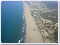 MAIN BEACHES
Antalya is famous for its long stretches of beach, most of them awarded with the Blue Flag. Patara in the east is the longest natural sandy beach. Phaselis and Adrasan are two other beaches famous for their natural beauty and ancient ruins. Konyaalti beach within the city boundary is a pebble beach and has also been awarded the Blue Flag. It has recently undergone a transformation and is now a popular hotspot for beach clubs and bars. It is the only project of its kind in Turkey. Side Incekum in the west is a very well-known sandy beach.
• Beaches to the east are: Patara, Kaputas, Çayagzi, Finike, Kumluca, Çirali, Adrasan, Tekirova, Phaselis, Çalticak, Topçam, Sarisu, Konyaalti
• To the west are: Lara, Belek, Kumköy, Kadriye, Ahmediye, Alara, Incekum, Alanya, Kaledran, Biçki, Koru Meydani, Hacimusa.
• To the west are: Lara, Belek, Kumköy, Kadriye, Ahmediye, Alara, Incekum, Alanya, Kaledran, Biçki, Koru Meydani, Hacimusa.
No comments:
Post a Comment